
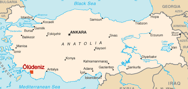
Oludeniz Map
Oludeniz is only a 45 minute drive from Dalaman Airport.
On leaving the airport follow the signs to Fethiye.
Following this route you will go through a toll tunnell and than by the pretty yachting town of GOcek. The road leads you up through picturesque mountains and you will descent towards Fethiye. Look out for sign to turn right towards Oludeniz & Fethiye. Stay on this road right through to the town and pass the bus station (on your right).
At the T-Junction turn left and follow this road directly up through Ovacik, HisarOnu and directly into Oludeniz.

-
This Oludeniz Map is available in PDF format
Download Map (300Kb)
Below is the distance chart of some locations from Fethiye.
Place |
Km. |
Miles |
| Dalaman Airport | 50 km. |
31.0 mil. |
| Ă–lĂĽdeniz | 12 km. |
7.4 mil. |
| Çalış Beach | 5 km. |
3.1 mil. |
| Göcek | 32 km. |
19.8 mil. |
| Antalya | 200 km. |
124.2 mil. |
| Kemer | 245 km. |
152.2 mil. |
| KaĹź | 105 km. |
65.2 mil. |
| Marmaris | 135 km. |
83.8 mil. |
| Bodrum | 265 km. |
164.6 mil. |
| Pamukkale | 230 km. |
142.9 mil. |
| Dalyan | 69 km. |
42.8 mil. |
| Ä°zmir | 365 km. |
226.8 mil. |
| Ä°stanbul | 800 km. |
497.0 mil. |
| Ankara | 650 km. |
403.8 mil. |

